 |
Editor’s note: This article will be updated twice a day — around 11 a.m. and 5 p.m. — or more frequently as needed. School district and community college closures are determined based on the latest information found on district and community college websites, as well as their Twitter and Facebook accounts when applicable. Are we missing something? Let us know by emailing alindenberg@ednc.org.
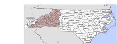
On Sunday, Sept. 29, President Biden granted Gov. Cooper’s request for a Federal Major Disaster Declaration for Hurricane Helene providing immediate federal help for 27 North Carolina counties and the Eastern Band of Cherokee Indians, according to this press release.
The disaster declaration includes Alexander, Alleghany, Ashe, Avery, Buncombe, Burke, Caldwell, Catawba, Clay, Cleveland, Gaston, Haywood, Henderson, Jackson, Lincoln, Macon, Madison, McDowell, Mecklenburg, Mitchell, Polk, Rutherford, Swain, Transylvania, Watauga, Wilkes, Yancey, and the Qualla Boundary.
“This is an unprecedented tragedy that requires an unprecedented response,” said Gov. Cooper in this press release.
School district closures and delays
These 31 school districts are covered by the federal disaster declaration.
- Alexander County Schools resumed a regular schedule on Oct. 2.
- Alleghany County Schools resumed a regular schedule on Oct. 8.
- Ashe County Schools opened for teacher workdays on Oct. 23 – Oct. 28. Students returned to school on a two-hour delay on Oct. 29 through Nov. 1.
- Asheville City Schools reopened on Monday, Oct. 28 on a modified schedule. Elementary Hours will be from 9:00 a.m. – 1:00 p.m. and secondary hours will be from 10:00 a.m. – 2:00 p.m.
- Avery County Schools reopened for students on Nov. 6.
- Buncombe County Schools opened for teacher workdays on Oct. 23 and 24. Students returned to school on a two-hour delay on Oct. 25 through Nov. 1.
- Burke County Schools operated with delayed openings for students on Oct. 9, 10, and 11. They resumed a regular schedule on Oct. 14.
- Caldwell County Schools resumed a regular schedule on Oct. 9.
- Catawba County Schools resumed a regular schedule on Oct. 4.
- Charlotte-Mecklenburg Schools resumed a regular schedule on Oct. 1.
- Cherokee Central School resumed a regular schedule on Oct. 7.
- Clay County Schools resumed a regular schedule on Sept. 30.
- Cleveland County Schools resumed a regular schedule on Oct. 7.
- Gaston County Schools resumed a regular schedule on Oct. 2.
- Haywood County Schools resumed a regular schedule on Oct. 16.
- Henderson County Public Schools resumed a regular schedule on Oct. 15.
- Hickory City Schools resumed a regular schedule on Oct. 7.
- Jackson County Schools resumed a regular schedule on Oct. 7.
- Lincoln County Schools resumed a regular schedule on Oct. 3.
- Macon County Schools resumed a regular schedule on Oct. 3.
- Madison County Schools reopened on a two-hour delay on Oct. 16.
- McDowell County Schools reopened for students except those attending Old Fort Elementary on Oct. 9 and operated on a two-hour delay through Oct. 11.
- Mitchell County Schools reopened on Nov. 7.
- Newton-Conover City Schools resumed a regular schedule on Oct. 2.
- Polk County Schools resumed a regular schedule on Oct. 9 with a two-hour delay. They are now operating on a regular schedule without delay.
- Rutherford County Schools operated on a two-hour delay on Oct. 9, and then returned to a normal operating schedule on Oct. 10.
- Swain County Schools resumed a regular schedule on Oct. 3.
- Transylvania County Schools resumed a regular schedule on Oct. 14.
- Watauga County Schools resumed a regular schedule on Oct. 24.
- Wilkes County Schools resumed a regular schedule on Oct. 3.
- Yancey County Schools reopened on Nov. 18th on a two-hour delay schedule.
Community college closures and delays
These 14 community colleges are covered by the federal disaster declaration.
- A-B Technical Community College reopened on Oct. 28 for all students, employees, and programs.
- Blue Ridge Community College resumed a regular schedule on Oct. 14.
- Caldwell Community College and Technical Institute‘s Caldwell Campus resumed a regular schedule on Oct. 7. The Watauga Campus remained closed Oct. 7 through Oct. 11.
- Catawba Valley Community College resumed normal operations on Oct. 5.
- Cleveland Community College returned to normal operations on Oct. 3. Fall break for students was through Oct. 4. Classes resumed on Oct. 7.
- Gaston College resumed a regular schedule on Oct. 1.
- Haywood Community College resumed a regular schedule on Oct. 16.
- Isothermal Community College resumed a regular schedule on Oct. 7.
- Mayland Community College resumed classes and services on Oct. 28.
- McDowell Technical Community College resumed a regular schedule on Oct. 14.
- Southwestern Community College resumed a regular schedule on Oct. 7.
- Tri-County Community College has resumed a regular schedule.
- Western Piedmont Community College reopened for employees on Oct. 7. Classes resumed for curriculum students on Oct. 9.
- Wilkes Community College‘s Wilkes campus and Alleghany Center resumed classes on Oct. 7, 2024. Ashe campus resumed classes on Oct. 14.
Are we missing something? Let us know by emailing alindenberg@ednc.org.
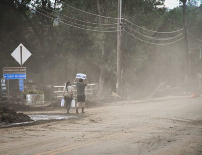
Hurricane Helene devastates Western North Carolina
“The catastrophic devastation to western North Carolina is like nothing we have ever seen,” said Gov. Cooper in this press release.
Gov. Roy Cooper issued a statewide State of Emergency on Wednesday, Sept. 25 as North Carolina braced for the arrival of Hurricane Helene. In addition, during the hurricane, 29 counties and 52 towns and cities were under a State of Emergency.
If you are trying to connect with missing family members or loved ones, call NC 211 (or 1-888-892-1162 if calling from outside the state).
People are urged to stay off Western North Carolina roads so that emergency responders, utility crews, and desperately needed supplies can get through. According to a press release, 280 state-maintained roads remain closed including parts of Interstate 40 and Interstate 26. You can find current roadway conditions by visiting DriveNC.Gov.
On Monday, Sept. 30, Gov. Cooper, FEMA Administrator Deanne Criswell, NCDOT Secretary Joey Hopkins, NCDPS Secretary Eddie Buffaloe, NCDHHS Secretary Kody Kinsley, and NC Emergency Management Officials were in Buncombe County to assess storm damage and ongoing response efforts in Western North Carolina. Here is a press release about the initial assessment.
Senate President Pro Tem Phil Berger, R-Rockingham, issued a statement on behalf of the Senate Republican Caucus, including “the General Assembly stands ready to take the necessary steps to help our neighbors in Western North Carolina.” Later on social media, he added, “North Carolina has a healthy savings account that will help us respond to the catastrophic nature of this storm.”
Superintendent Catherine Truitt and the leadership team at the N.C. Department of Public Instruction are mobilizing to secure attendance and testing waivers along with HR, nutrition, transportation, and financial support for the impacted schools.
To donate to the North Carolina Disaster Relief Fund, visit nc.gov/donate.
How to apply for FEMA assistance
If you live in the 25 counties impacted by the hurricane and have uninsured damage, here is what you need to know about applying for federal assistance.
Staying safe and alert during severe weather
North Carolina residents are advised to stay aware during the recovery.
State officials advise these tips to make sure your family is prepared:
- Have multiple ways to receive emergency information, including watches and warnings. Make sure emergency alerts are enabled on your cell phone and monitor local new outlets and the National Weather Service.
- Ensure that you have multiple ways to receive warnings, especially with the potential for severe storms to be moving through during nighttime hours.
- Have an emergency plan. Know where you would go if you need to evacuate, especially if you live in a flood prone area.
- Gather emergency supplies or refresh your emergency kit. Visit ReadyNC.gov for info on how to build an emergency kit.
- Never drive through flooded roadways or around barricades. Turn around. Don’t drown.
- Make sure you know where to seek shelter if a tornado warning is issued for your area.
- Check to see if your local emergency management office offers emergency alert services for its residents. You can visit your county government website for more information.
Avoid unnecessary travel. You can find current roadway conditions by visiting DriveNC.Gov.
EdNC’s reporting as the hurricane approached
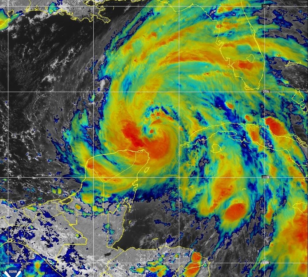
Current forecasts show Helene bringing the potential of flooding, landslides, and tornadoes to western and central North Carolina. The storm is expected to arrive on Thursday evening and continue into Friday.
“Helene threatens heavy rain, flash flooding, landslides, and damaging winds to the mountains and Piedmont areas of our state,” said Cooper in a press release. “Now is the time for North Carolinians to prepare, make sure emergency kits are up-to-date and pay attention to the weather alerts in your area.”
North Carolina residents are advised to stay aware and keep a watch on the forecast.
As Hurricane Helene approaches North Carolina, EdNC is working to track closures and delays at our state’s schools and community colleges. We will keep you informed on Helene’s impact on schools, students, and communities.
The Department of Public Safety held a news briefing on Sept. 26 providing updates and advice as Helene approaches North Carolina.
You can view Gov. Cooper’s remarks from the briefing by expanding the toggle below.
Gov. Cooper’s remarks
“We want to take this time to give you the latest updates on Hurricane Helene as it closes in on North Carolina. This is an unusually dangerous storm that threatens to bring heavy rain and potentially catastrophic flooding tonight and tomorrow for central and particularly western North Carolina.
When tropical weather crosses into our mountains, it can be deadly. Just a few years ago, Tropical Storm Fred shocked our mountain regions with torrential rain sweeping away homes, bridges and lives. With Helene, this can happen again. Just last week, we were reminded of the unpredictability of severe weather in North Carolina as a coastal storm brought 20 plus inches of rain on parts of southeastern North Carolina.
With Hurricane Helene, we have to be clear here. heavy rains and winds are coming. Beware and prepare. Travel will be dangerous. Flooding is likely, and we are preparing for unexpected conditions. Our thoughts are with our friends in Florida and other southern states that are being hit first, and our priority here is to protect lives and manage the impact of the storm on our communities here in our state.
As it arrives, Helene is forecast to bring more than a foot of rain to parts of western North Carolina, which will likely cause significant flash flooding, landslides, damaging debris flows, slope failures across steep terrain and river flooding. Even areas that don’t typically experience it may see flooding. Cities like Charlotte and Asheville could see flash flooding despite not being in the storm’s direct path.
To prepare, all North Carolinians should tune into weather alerts today and through the weekend. Tropical storm force winds are possible across western North Carolina later today and into Friday. With already saturated soils from earlier rains, falling trees could cause widespread power outages. As of this morning, there are about 14,000 estimated power outages statewide.
There is the potential for tornadoes with this storm system as well, which can quickly spin up with little warning. This storm path is wide and its impacts will be felt far from the center of the storm. The North Carolina State Emergency Operations Center is communicating with local leaders and emergency management teams across our state.
I’ve activated 175 soldiers and airmen from the North Carolina National Guard, and we’ve deployed North Carolina’s swift water rescue teams and urban search and rescue teams to assist in the response and to save lives. Our Department of Transportation is standing ready to respond to road closures and repair the damage. We’ve spoken to Duke Energy and know that line workers are standing by to restore power.
Yesterday, I declared a state of emergency to help move supplies like water, food and medicine, heavy equipment and to support agricultural operations before the storm arrives. If you do not need to travel, please stay off the roadways, especially in the foothills and the mountains. Do not drive through flood waters.
We have lost too many North Carolinians who have driven around barricades and into flood waters, including one just last week in Brunswick County. You cannot tell the depth of water just by looking at it from your vehicle. Turn around. Don’t drown.
If you are told to evacuate, get out of the danger zone. Make a plan now to stay with friends or family if you are in an area that could likely be flooded and I think that there are a number of these in the mountains that could be this way.
Please stay informed to protect yourself and your family.”